GPS, GIS and Nav (Oh my!)
This book contains information about navigation, GPS, GIS tools like QGIS etc.
- Setting the Map Datum to GDA 94 on Garmin watches
- Add Sixmaps mapping layer to QGIS
- Importing Threatned Plant and Animal Species
- NSW 2022 Topographic GeoPDF Maps - Direct Download Links
Setting the Map Datum to GDA 94 on Garmin watches
Ok, because this is typically a "Set once and forget" setting, it will be easy to forget it in the future when you get a new watch or if you need to reset to factory defaults.
The default map Geocentric Datum of Australia is GDA94 and is the same we use in the RFS. That means the latitude/longitude grid reference on our printed maps are the same on the watch face.
To set the GPS display format on the watch:
Now when you long-press the GPS button it will display a 10 figure grid reference. For example:
Position:
56H KH 63241
MGRS 67108
Alt. 709
Map Datum Supported by Garmin GPS Devices
https://support.garmin.com/en-AU/?faq=CuRXNp4JBU25QHE8cwRI26
Add Sixmaps mapping layer to QGIS
Download the QLR file in the attachments on this page, then drag it onto the QGIS program window and the later will be added to the open project.
Attachments
| SIX maps Public NSW Imagery QGIS Layer | Sixmaps_Public_NSW_Imagery.qlr |
| ArcGIS REST Services Directory | |
|
Complete ArcGIS Config for QGIS [Best Choice] |
|
| Example Project |
ArcGIS REST Services
To import these into QGIS:
ArcGIS REST Services - SIX Maps.xml file to your computer.Manually Adding the Layers to QGIS (Web Services)
- Retrieve the WMS URL for the service you want to use from its REST endpoint.
e.g. Visit NSW Imagery REST Endpoint - Look for the WMS link towards the top left of the page. Right-click + copy link address or left-click the link to open the link and copy the URL from the address bar.

- In QGIS, click the "Add WMS/WMTS Layer" button in the 'Layers' toolbar.

-
From the dialogue select the 'New' button.

- Enter a name for the connection and the service's WMS URL, then click 'OK'.

-
Click the 'Connect' button, to fetch the details of the WMS service. Click to highlight the layer you want to add, then check the Coordinate system listen in the bottom pane.
-
Click the 'Change' button, and select 'EPSG:3857' from the dialog. Hit OK, then click the 'Add' button at the bottom of the 'Add Layer' dialog.

-
This will add it to your map. You can now close the 'Add Layer' dialog.


Obtaining New Maps from the Interwebs
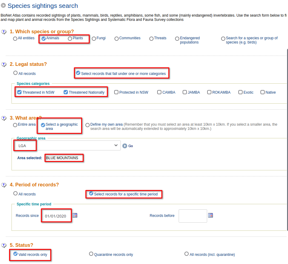
Importing Threatned Plant and Animal Species
- Open the Bionet Atlas
- Enter the search parameters

- Click on Download Records, for a sanity check you have checked the right items you can click the View Map.
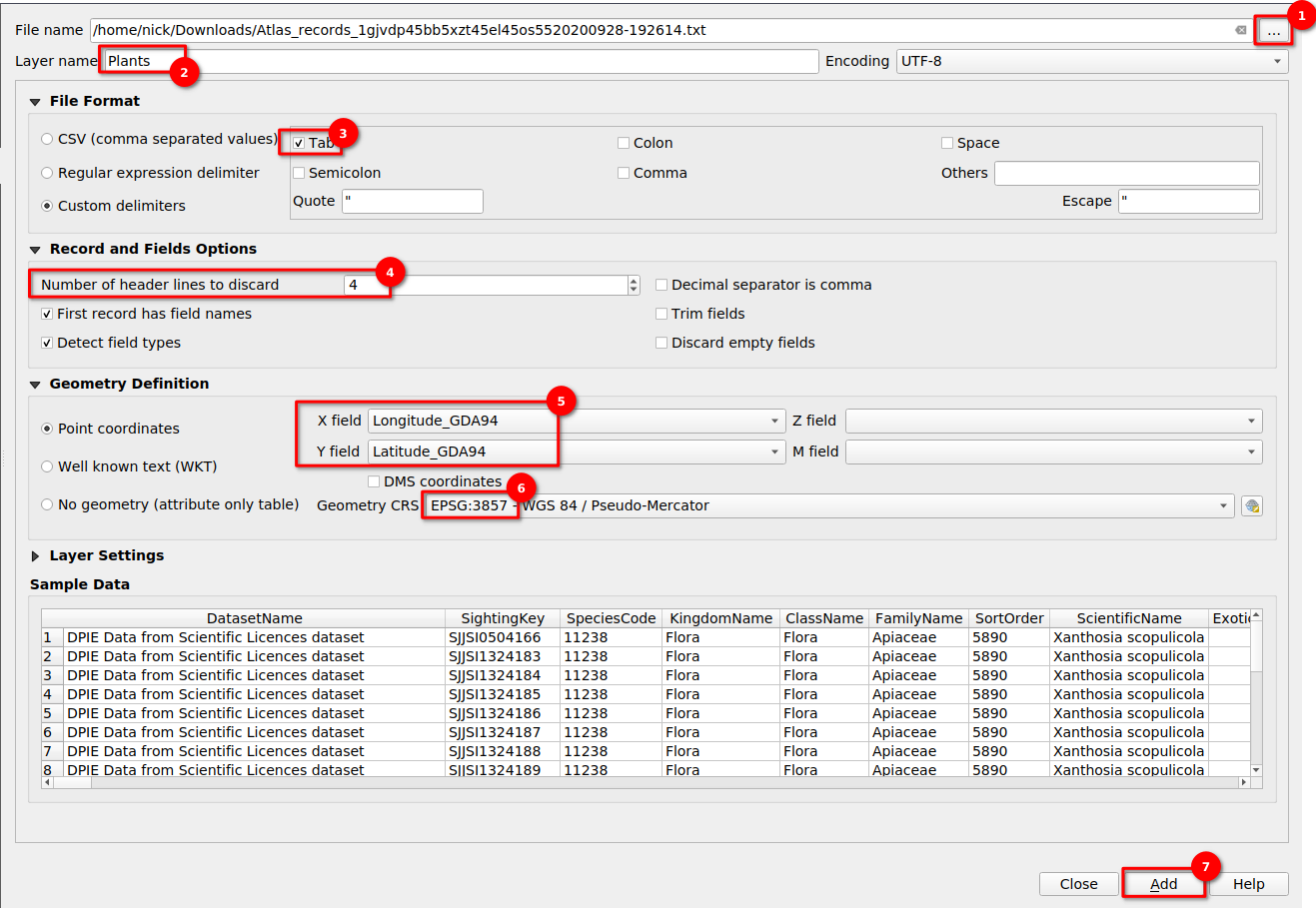
- Then you need to unzip the file, there should be a TAB delimited TXT file
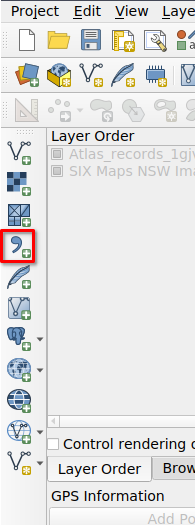
- In QGIS, click the Add Delimited Text Layer
Ctrl + Shift + Tbutton
- Browse for the file, then:
- Browse for file
- Layer name
- Tab-delimited
- Header lines to discard
- Coordinates
- Change to EPSG:3857
-

Troubleshooting
If the items don't appear on the map, edit the layer properties and change the Coordinate Reference System (CRS) to EPSG:4939 - GDA94.

NSW 2022 Topographic GeoPDF Maps - Direct Download Links
Source
- Obtained through the Spacial Information Exchange website, other viewers
- Other tools like historic aerial imagery are here
- See page attachments on the left for file downloads
GeoPDFs including the Collar (Border/Legend etc)
See the attached spreadsheet for GeoTIF images that have no collar.
If any of the links below do not work. Please visit the Spacial Information Exchange catalog, or try the 2017 edition maps on the eTopo site.